


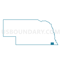
Pawnee Precinct 2, Pawnee County, Nebraska
About
Outline

Summary
| Unique Area Identifier | 613683 |
| Name | Pawnee Precinct 2 |
| County | Pawnee County |
| State | Nebraska |
| Area (square miles) | 62.21 |
| Land Area (square miles) | 62.17 |
| Water Area (square miles) | 0.04 |
| % of Land Area | 99.93 |
| % of Water Area | 0.07 |
| Latitude of the Internal Point | 40.12517430 |
| Longtitude of the Internal Point | -96.14043350 |
Maps


Graphs
Select a template below for downloading or customizing gragh for Pawnee Precinct 2, Pawnee County, Nebraska


Neighbors
Neighoring Voting District (by Name) Neighboring Voting District on the Map
- Burchard Precinct, Pawnee County, NE
- Franklin/Humboldt Rural/Speiser Precinct, Richardson County, NE
- Pawnee Precinct 1, Pawnee County, NE
- Steinauer Precinct, Pawnee County, NE
- Table Rock Precinct, Pawnee County, NE
Top 10 Neighboring County Subdivision (by Population) Neighboring County Subdivision on the Map
- Precinct 2, Pawnee No. 2, Pawnee County, NE (802)
- Precinct 1, Pawnee No. 1, Pawnee County, NE (412)
- Precinct 3, Table Rock, Pawnee County, NE (409)
- Precinct 5, Burchard, Pawnee County, NE (394)
- Precinct 4, Steinauer, Pawnee County, NE (334)
- Precinct 6, South Fork, Pawnee County, NE (254)
- Humboldt precinct, Richardson County, NE (144)
- Speiser precinct, Richardson County, NE (89)
Top 10 Neighboring Place (by Population) Neighboring Place on the Map
Top 10 Neighboring Unified School District (by Population) Neighboring Unified School District on the Map
- Humboldt Table Rock Steinauer Public Schools, NE (3,300)
- Pawnee City Public Schools, NE (1,566)
- Lewiston Consolidated Schools, NE (1,021)